Satellite mapping of every building’s function in urban China reveals deep built environment disparities
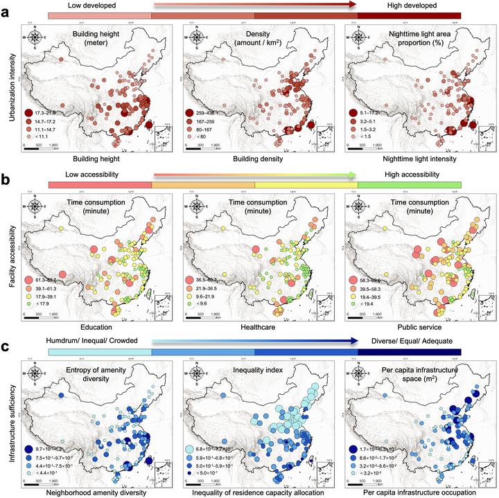 Multi-dimensional assessment of built environment disparities in 109 cities across China. Each row presents three indicators corresponding to one of the three dimensions at the national scale; legends are provided in the bottom-left corner of each map.
Abstract
Decades of rapid urbanization have reshaped China’s cities, yet fine-scale built environment disparities remain unclear due to scarce building-level data. Here, we present SinoBF-1, a national building functional map of China that delineates 110 million buildings across 109 major cities using 1-meter multi-modal satellite data. Using nine indicators spanning urbanization intensity, facility accessibility, and infrastructure sufficiency, we quantify disparities across city tiers, geographic regions, and intra-city zones. Analyses reveal that Across city tiers, accessibility and amenity diversity decline sharply from top- to low-tier cities, while mid tiers show more equitable housing allocation; Geographically, southern cities exhibit the highest access to healthcare, education, and public services but suffer from infrastructure overcrowding; and Within cities, later-expanding zones exhibit greater disparities than early-established urban cores. This study reflects legacies of national development policies over the past half-century and offers a framework for evaluating urban inequality in rapidly urbanizing regions.
Zhuohong Li
Postdoc Associate
My research interest focuses on remote sensing of ecology.